VanderSat will provide Dutch Water Authority with unique high-precision water data
April 24, 2018
utch Water Authority Aa en Maas and the Dutch company VanderSat signed an agreement to improve water management and lower costs associated with flooding events through precise satellite data-based water information. Aa en Maas will utilize two of VanderSat’s unique satellite data services. Soil moisture monitoring to get a clear overview of the water authority’s soil moisture distribution. Inundation monitoring to lower the costs associated with damage assessment and to pro-actively detect flood prone areas.
In a research phase of one year, both organisations have worked on validating the VanderSat services. The service will now be rolled out to the entire water authority.
“Knowing about soil moisture is a key variable for a more precise management of our water distribution”, says Pim van Santen, researcher at Aa en Maas. “Including VanderSat’s data and expertise into our operations, people will benefit from even more precise, consistent information and predictions – also in areas with a sparse ground sensor network or when there are cloudy conditions. Also, it will help the water authority save costs and time, for example to install ground sensors or weather stations, and it will help increase the accuracy of a damage assessment of flooded areas in case of such an event.
Unmatched accuracy helps water managers take better decisions
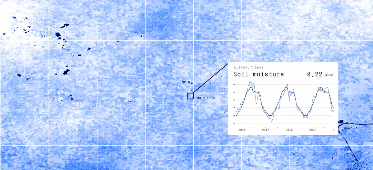
“One major advantage of using microwave data is that measurement from space is not interfered by cloud cover“, says Richard de Jeu, founder and Chief Technology Officer of VanderSat. “By collecting daily information on soil moisture via different satellites and over a longer period, we have built up a historical archive which goes back 16 years.” Also, last year’s validation phase highlighted that satellite data using VanderSat’s technology are typically more consistent, scalable and representative than models using weather stations or other sensors in the field. “The combination of high resolution, no cloud cover issues, and a historical database makes our model highly reliable for calculating for example flood models. Also our unique inundation monitoring service will lower the costs of damage assessment and will lead to more pro-active water management because the historic data clearly tells the water authority where the flood prone areas are.”, de Jeu concludes.
“VanderSat’s unique satellite data will provide an independent layer of information to further improve our water management,” says Pim van Santen. VanderSat provides data with a spatial resolution of 100×100 meters on a daily basis for every place on earth globally and a resolution of 10×10 meter for the inundation service.
About VanderSat
How VanderSats Technology works
VanderSat observes water and temperature at field scale across the globe using satellites. Every day, everywhere on earth, with unmatched accuracy. Soil moisture, the water content of the vegetation, inundation and land surface temperature. Near real time, globally and daily without cloud interference. VanderSat’s satellite data can be accessed easily through the API and viewer and is up to 1000 times cheaper than traditional ground sensors.
It is VanderSat’s mission build the best satellite products to solve the global water and food crisis and always keep innovating. VanderSat is working with the biggest players in agriculture, insurance, water management and humanitarian aid in order to have the biggest positive impact. VanderSat is based in the Netherlands and is unique in it’s patented ability to deliver high resolution data on soil moisture, temperature and vegetation water content on a global scale.
About Dutch Water Authority Aa en Maas
Aa en Maas is a so-called ‘waterschap’ and provides water system management, waste water treatment and safety against flooding for more than 700.000 people in the east of the province of North-Brabant in the Netherlands.
Better water management and detection of flooding events with microwave satellite data.
- VanderSat’s microwave sensing from space will help to get a clear view of current and past soil moisture distribution and to actively monitor flooding events with satellites, also in the event of cloudy conditions.
- VanderSat API integration into the Water Authority’s systems to improve water management and lower costs for flooding detection and damage assessment.
- Aa en Maas en VanderSat have been working together since 2015 through the Beta Program